Rozovsky district ( Ukrainian: Rozivsky district ) - the administrative unit of the Zaporizhzhya region of Ukraine .
| area | |||||
| Rozovsky district | |||||
|---|---|---|---|---|---|
| Rozivsky district | |||||
| |||||
| A country | Ukraine | ||||
| Included in | Zaporizhzhya region | ||||
| Includes | 1 village council 7 village councils | ||||
| Adm. Centre | Rosovka | ||||
| The head of administration | Popov Vladimir Alexandrovich | ||||
| History and Geography | |||||
| Date of formation | 1992 year | ||||
| Square | 610 km² | ||||
| Timezone | , in the summer | ||||
| Population | |||||
| Population | 8 781 [1] people ( 2017 ) | ||||
| Digital identifiers | |||||
| Telephone code | +380 6162 | ||||
| Postal codes | 70304 | ||||
| Auto Code numbers | AR | ||||
| KOATUU | 2324900000 all codes | ||||
 | |||||
 | |||||
![Flag [d]](http://upload.wikimedia.org/wikipedia/commons/thumb/e/eb/Rozivskiy_rayon_prapor.png/160px-Rozivskiy_rayon_prapor.png)
![Coat of arms [d]](http://upload.wikimedia.org/wikipedia/commons/thumb/d/d1/Rozivskiy_rayon_gerb.png/90px-Rozivskiy_rayon_gerb.png)
The administrative center is the urban-type settlement Rozovka .
Content
Geographical position
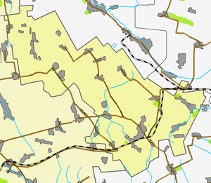
Rozovsky district is located in the eastern part of Zaporizhzhya region . The area is bordered by:
- in Donetsk region :
- in the northeast with the Velikonovoselkovsky district ,
- in the east with the Volnovakhsky district ,
- in the south and southeast with the Nikolsky district ;
- in Zaporizhzhya region:
- in the west and southwest with the Bilmak region and
- in the north with the Gulyaypolsky area .
The area of the district is 610 km².
The rivers flow through the district: Kalchik , Karatysh , Sukhoi Yaly .
The climate is warm and temperate continental .
History
The area was established on June 26, 1992 in accordance with the Decree of the Verkhovna Rada of Ukraine of June 26, 1992 No. 2505-XII.
Population
As of January 1, 2011, the population was 9647 people (of whom 3516 lived in urban conditions and 6131 in rural conditions), as of January 1, 2013 - 9316 people [2] .
Administrative device
The area includes [3] :
|
|
Local councils [4]
|
|
Settlements [5]
pos. Azov | with. Zaporizhzhya | with. Listvyanka | with. Novozlatopol |
Links
Notes
- ↑ Number of population (per estimate) for 1 birch tree 2017 year archive Archived May 9, 2017 on Wayback Machine // Head statistics department in Zaporizhzhya region
- ↑ The number of the explicit population of Ukraine on 1 September 2013. State Statistics Service of Ukraine. Kiev, 2013. 64
- ↑ According to the district’s registration card on the website of the Verkhovna Rada of Ukraine. (inaccessible link)
- ↑ Regions of Ukraine and that warehouse (inaccessible link)
- ↑ Warehouse of administrative and territorial units (inaccessible link)