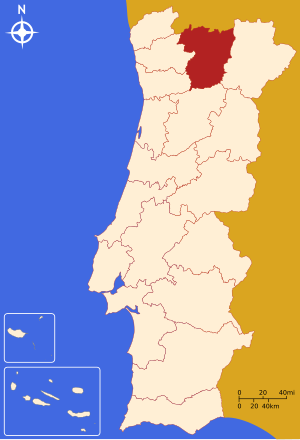
Vila Real County ( port. Distrito de Vila Real ) is a county in northern Portugal . The district consists of 14 municipalities. Included in the Northern region . It is distributed between three statistical subregions: Altu-Traz-Ush-Montes , Douro , Tamega . Previously, it was part of the province of Traz-u-Montis-i-Altu-Douro . Territory - 4309 km². The population is 206,661 people (2011). The population density is 47.96 people / km². The administrative center is the city of Vila Real .
| County | |
| Vila Real County | |
|---|---|
| port. Distrito de vila real | |
| A country | Portugal |
| Included in | Northern region |
| Includes | 14 municipalities |
| Adm. center | Vila Real |
| History and Geography | |
| Area | 4,309 km² |
Height
|
|
| Timezone | UTC + 0 |
| Population | |
| Population | 206 661 people ( 2011 ) ( 14th place ) |
| Density | 47.96 people / km² (14th place) |
| Digital identifiers | |
| ISO 3166-2 Code | PT-17 |
| Official site | |
 | |
Content
- 1 Geography
- 2 Municipalities
- 3 See also
- 4 References
Geography
The region borders:
- in the north - Spain
- in the east - Braganca district
- in the south - Viseu County
- in the west - the districts of Braga and Porto
Municipalities
The district includes 14 municipalities:
- Mondin de Bashtu
- Chavish
- Montalegre
- Santa Marta de Penagian
- Sabroza
- Mezan Friou
- Ribeira de Pena
- Aligo
- Botikash
- Vila Real
- Vila Poca de Aguiar
- Valpasos
- Mursa
- Pesu da Regua
See also
- Municipalities of Vila Real County
- Korgu Line (Railway)