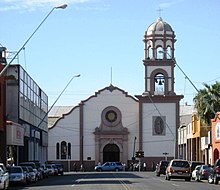
Mexicali ( Spanish: Mexicali ) - a city in the municipality of Mexico City, the administrative center of the state of Baja California . The population is 689,775 people. Located on the border with the US state of California . The name of the city is a combination of the Spanish pronunciation of México and California. On the other side of the border, from the US side, its sister city is located - Calexico (collocation California and Mexico).
| City | ||||||||
| Mexicali | ||||||||
|---|---|---|---|---|---|---|---|---|
| Mexicali | ||||||||
| ||||||||
| ||||||||
| A country | ||||||||
| State | Baja California | |||||||
| Municipality | Mexicali | |||||||
| Mayor | Jaime Diaz Ochoa | |||||||
| History and geography | ||||||||
| Based | March 14, 1903 | |||||||
| Square | 113.7 km² | |||||||
| Center height | 8 m | |||||||
| Climate type | arid | |||||||
| Timezone | UTC-8 , in summer UTC-7 | |||||||
| Population | ||||||||
| Population | 689 775 people ( 2010 ) | |||||||
| Density | 81.94 people / km² | |||||||
| Agglomeration | 996,826 people | |||||||
| Katoykonim | Mexicalense, Cachanilla. | |||||||
| Digital identifiers | ||||||||
| Telephone code | +52 686 | |||||||
| Zip Codes | 21000-21399 | |||||||
| mexicali.gob.mx (Spanish) | ||||||||


In the city there are various enterprises of food, textile, automobile, aerospace industries, there are also cultural and educational institutions. Developed transport infrastructure. The city is served by General Rodolfo Sanchez Taboada International Airport .
Content
History
The Spaniards arrived in this area after passing the Devil's Road ("Camino del Diablo") of the Sonora desert. This led to the evangelization of the indigenous population of the peninsula, as well as to a reduction in the population of indigenous peoples. Small Cocopah communities have survived. The presence of Europeans at that time was limited to the Jesuits, who left in the 1780s. After that, the Spaniards, and later the Mexicans, had little in common with the northeastern part of the Baja California peninsula, perceiving it as indomitable land. In the middle of the XIX century. geological work was carried out, which took place here for the construction of the South Pacific Railway. Sedimentary deposits were found here. However, from that time until the 1880s. the area was almost completely unpopulated, mainly due to the climate. In 1888, the federal government provided most of the northern part of the state, including Mexicali G. Andrade, with the goal of colonizing the area on the newly organized US border. In 1900, the American California Development Company received permission from the P. Dyas government to cut a canal through the Aroyo Alamo Delta to connect a dry basin to the Colorado River. New settlers and farmers who were given land were brought here. Already in 1904, 405 km² of the valley was irrigated. Here began to grow cotton, fruits and vegetables. On both sides of the border, settlements were formed: on the American side - Calexico, on the Mexican - Mexicali. The official founding date of Mexicali is March 14, 1903. Agricultural production continued to grow during the 20th century. Foreigners were attracted here - Indians and Japanese. Here the textile industry began to develop. In 1952, after the formation of the state of Baja California, Mexicali became the capital of this federal subject. Mexicali is an important center of industrial production in the automotive, aerospace, telecommunications, metallurgical and medical industries, as well as in the production and export of products.
Climate
The climate is dry, deserted, with warm winters and sultry summers. The average annual rainfall is 84 mm.
| Climate Mexicali [1] | |||||||||||||
|---|---|---|---|---|---|---|---|---|---|---|---|---|---|
| Month | Jan | Feb | Mar | Apr | May | Jun | Jul | Aug | Sen | Oct | But I | Dec | Year |
| Wed max. ° C | 20.3 | 23.1 | 25.8 | 29.7 | 34.7 | 40.1 | 42,2 | 41,4 | 38.2 | 32,0 | 24.9 | 20.3 | 31.1 |
| Wed min. ° C | 6.0 | 8.0 | 10.3 | 13.1 | 16.8 | 21.2 | 25.6 | 25.6 | 22.4 | 16.3 | 9.6 | 5.8 | 15.1 |
| Precipitation, mm | eleven | eight | eight | 2 | one | 0 | five | 12 | ten | 9 | four | 13 | 84 |
See also
- American channel