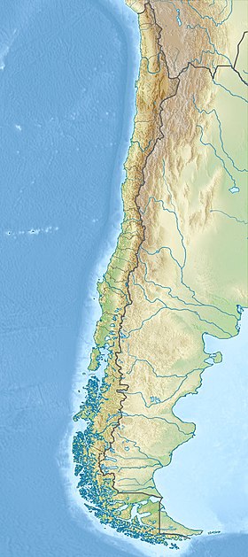
Robinson Crusoe ( Spanish Isla Robinsón Crusoe ) - one of the three islands of the Juan Fernandez archipelago (an area of 47.9 km²). It is located in the southeastern Pacific Ocean , 674 km west of the coast of Chile . Until 1966, it was called Isla Más a Tierra (Rus. Mas-a-Tierra , "the island closest to the earth").
| Robinson Crusoe | |
|---|---|
| Spanish Isla Robinsón Crusoe | |
 Robinson Crusoe Island on a Map of the Southeast Pacific | |
| Characteristics | |
| Area | 47.9 km² |
| Highest point | 916 m |
| Population | 630 people (2002) |
| Population density | 13.15 people / km² |
| Location | |
| Archipelago | Juan Fernandez Islands |
| Water area | Pacific Ocean |
| A country |
|
| Region | Valparaiso |
| Provinces | Valparaiso |
Content
- 1 Description
- 2 History
- 3 Our days
- 4 notes
- 5 Links
Description
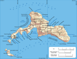
As a result of volcanic activity and wind erosion, the island has a mountainous topography. The highest point of the island is Mount El Yunque, 916 meters above sea level. The southwestern part of the island ends in the narrow peninsula of Cordon Escarpado. One and a half kilometers southwest of the island of Robinson Crusoe is another island of the archipelago - the island of Santa Clara . The third island of the archipelago, Alexander Selkirk , is located 150 km west of the first two.
The climate of the island is Mediterranean. Air temperature ranges from + 3 ° C to + 30 ° C. On different sides of the middle ridge, the climate is very different. The eastern and middle parts of the island have a warmer, humid climate. The western part is colder, drier and deserted. The population is concentrated in a small area on the shore of the bay in the central part of the island, covered on three sides by mountains. The climate in this part is the warmest and wettest. The island has rich flora and fauna. Some species are unique examples of island nature. The coastal waters are rich in a wide variety of marine life. A large colony of fur seals lives on the island.
History
In 1704, the Scottish sailor Alexander Selkirk landed on the island, who lived on it for 4 years and 4 months in complete solitude. Writer Daniel Defoe used his life story as the basis for his novel Robinson Crusoe . The name of his main character is now an island. In addition to Selkirk, which became the prototype of Robinson, other Robinsons repeatedly landed on the island in different years, both before Selkirk and after it, both alone and in groups. Some of them lived alone for more than years than Selkirk himself. The island, in different years, has repeatedly become a haven of pirates who used it as a base for recreation, ship repair and replenishment of food and fresh water.
In 1749, the Spaniards built the stone fort Santa Bárbara on the island to protect themselves from pirates. The fort has survived to this day, as well as 15 cannons of those times.
During the First World War , on March 14, 1915, a short naval battle took place near the island. The German armored cruiser Dresden was blocked at Cumberland Bay, by the British cruisers Kent and Glasgow, accepted the battle and sank. The crew was interned in Chile. The future head of the Abwehr of the Third Reich and the future admiral Wilhelm Canaris , who later was exposed at the very end of World War II , was exposed and executed for many years of cooperation with British intelligence, served on board the cruiser.
Our days
Most of the island's 630 inhabitants (2002) live in the village of San Juan Bautista, located in the center of the northern coast. The main activities are lobster fishing and tourist services. Hundreds of tourists visit the island every year, mainly under the influence of the novel Robinson Crusoe. Scuba diving is very popular among tourists, the main purpose of which is to inspect the remains of the German cruiser Dresden , sunken in the Cumberland Bay during the First World War. The island even has its own brewery.
However, in general, the infrastructure for tourism is poorly developed. There are no sandy beaches on the island at all. Bathing water is cool. Weather conditions do not favor “beach” tourism for most of the year. There are hotels for unassuming tourists. But tourists do not go to the island for a swim. Their goal is to touch history, the pristine, in many ways unique, island nature, feel the greatness of the ocean, try to imagine yourself in the place of the “real Robinson”, at least for a few days.
There are almost no paved roads on the island. Dirt roads cover only a small part of the territory of direct interest to the local population. In the remote part of the island, on the Cordon-Escarpado peninsula, 10 km from the village - in a straight line, through the mountains, right on the side of the mountain - a regional airfield was built, not connected with the village by land roads. The airfield runway, 860 mx 18 m, with hard surface, is capable of receiving only light regional aircraft. The service is regular, but it depends heavily on the weather on the island. Flights to / from Santiago and Valparaiso are operated by ATA Aerolineas (from the private Tobalaba airfield in Santiago) and LASSA on Beechcraft King Air 200 airplanes. Flight time is about two and a half hours. Communication between the airfield and the village is carried out by boat by sea. Travel time - from one and a half to three hours, depending on the path chosen to bypass the island. There is no regular maritime communication with the island. Once a year, a ship arrives from Chile to the island with the goal of importing fuel, food and other goods to support the livelihoods of the local population and infrastructure.
February 27, 2010 the island was affected by the tsunami caused by the earthquake in Chile . In San Juan Bautista, 8 people died [1] . The wave height reached five meters, many buildings were destroyed by water. [2] .
The architecture of the village is extremely unpretentious. After the tsunami, which washed away many houses, the houses here began to be built higher in the mountainous terrain. Typical wooden houses are common, as well as the "self-building", which are installed on the slopes on long piles - in order to save resources on leveling the soil for construction. Everything looks very poor, extremely primitive, which, however, is much closer to the "Robinson era" than to the gloss of modern resorts [3] .
Notes
- ↑ Tsunami warning came too late for Robinson Crusoe Island - Feature | Earth times news
- ↑ Tsunami sur l'île Robinson Crusoé: “la moitié du village emportée” unopened (link not available) . varmatin.com . Date of treatment March 10, 2010. Archived January 5, 2013.
- ↑ https://2f.ru/2012/12/20/ostrov-robinzona-kruzo-1/
Links
- Robinson Crusoe Island Description of the island of Mas a Tierra (Chile), which served as the prototype of Robinson Crusoe Island
- Photo from Robinson Crusoe Island. (English) Checked 10-03-2010
- Tsunami on the island (English) (inaccessible link) . Archived July 5, 2006. February 27, 2010. Audio-photo report of the American-Chilean group of student journalists. Checked 10-03-2010
- Report of a Russian tourist who visited the island in 2013. Allows you to eliminate many inaccuracies, distorted facts on the subject, found in abundance on the network. Contains a lot of photos.