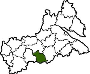
Katerinopolsky district ( Ukrainian: Katerinopolsky district ) is an administrative unit in the south of the Cherkasy region of Ukraine . The administrative center is the urban-type village of Katerinopol .
| area | |||||
| Katerinopolsky district | |||||
|---|---|---|---|---|---|
| Katerynopilskyi district | |||||
| |||||
| A country | Ukraine | ||||
| Included in | Cherkasy region | ||||
| Adm. center | Katerinopol | ||||
| History and Geography | |||||
| Date of formation | |||||
| Area | 725 km² | ||||
| Timezone | EET ( UTC + 2 , summer UTC + 3 ) | ||||
| Population | |||||
| Population | 23 661 [1] people ( 2018 ) | ||||
| Official language | Ukrainian | ||||
| Digital identifiers | |||||
| Postal codes | |||||
 | |||||

Content
- 1 Geography
- 2 History
- 3 Demographics
- 4 Administrative device
- 4.1 Settlements
- 5 Economics
- 6 Transport
- 7 Bibliography
- 8 Notes
- 9 References
Geography
Area - 725 km 2 .
History
Demographics
The population of the district is 29 thousand people ( 2005 data), including about 11 thousand people living in urban conditions. In total, there are 33 settlements.
Administrative device
Settlements
- 29 villages: Brodetskoye • Verbovets • Goncharich • Grushkovka • Gulyaypole • Elizavetka • Zaliznyachka • Kaitanovka • Kiselevka • Kobylyanka • Fox fox • Onion • Lovage • Wet Kaligorka • Elevation • Novoselitsa • Oknino • Palochok • Rassochokovka • Petrachokovka • Rassochokovka • Petrachekovka • Stiykovo • Stupichnaya • Dry Kaligorka • Shestakovo • Yampol • Yaroshovka
- 2 urban-type villages: Yerky • Katerinopol
- 2 villages: Novoukrainka • Chervony Brod
Economics
Transport
Bibliography
Notes
- ↑ Population (per estimate) for the 1st grass of 2018 rock // Head of statistics department in Cherkasy region