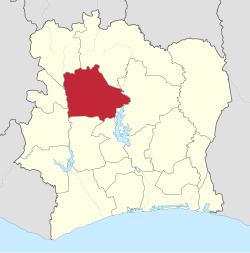
Vorodugu ( fr. Worodougou ) - an area in the central part of Cote d'Ivoire .
- The administrative center is the city of Segela .
- The area is 22 166 km² , the population is 536 012 people ( 2010 ).
| region | |
| Vorodugu | |
|---|---|
| fr Worodougou | |
| A country | Ivory Coast |
| Includes | 3 departments |
| Adm Centre | Segela |
| History and geography | |
| Square | 22 166 km² (5th place ) |
| Height | |
| Timezone | UTC + 0 |
| Population | |
| Population | 536 012 people ( 2010 ) ( 17th place ) |
| Density | 24.18 people / km² (17th place) |
| Digital identifiers | |
| ISO 3166-2 code | CI-14 |
 | |
Geography
In the north it borders on the Sawan region, in the east on the Valle du Bundam region , in the south on the Maraue and O-Sassandra regions, in the south-west on the Montagne region, in the west on the Ba-Sassandra region , in the north-west on the Dengel region .
Administrative division
The region is divided into 3 departments:
- Mancono
- Segela
- Kunahiri (since 2005)