Tsipa ( Upper Tsipa , Lower Tsipa ) is a river in the north of Buryatia , the left tributary of the Vitim . Flows through the territory of the Bauntovsky Evenk district . Length - 692 [2] km). The basin area is 42,200 [2] km².
| Tsipa | |
|---|---|
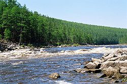 Threshold 47 on Tsip Threshold 47 on Tsip | |
| Characteristic | |
| Length | 692 km |
| Pool | 42,200 km² |
| Water flow | 270 m³ / s |
| Watercourse | |
| Source(T) (B) | |
| • Location | South Muysky Range |
| • Height | > 1962 m |
| • Coordinates | |
| Mouth | Vitim |
| • Height | <551 m |
| • Coordinates | |
| Location | |
| Water system | Vitim → Lena → More Laptev |
| A country |
|
| Region | Buryatia |
| Area | Bauntovsky Evenk District |
| HWR Code | |

Food mainly rain. Average water consumption 270 m / s. It freezes in October, opens in May, sometimes in June. In the upper reaches it freezes for 3-5.5 months [3] .
It originates on the western slope of the South Muya Range at an altitude above 1962 m Num [4] . The first 220 km to the Uyu weather station flows very slowly (0.4 m / s maximum) through the Baunt Basin .
Further, Tsipa, sandwiched from all sides by ridges, winds strongly, gaining strength before breaking through the mountains of Babant . On this site 119 obstacles in the form of rapids and shiver are located . In general, very large shafts up to 4 meters and barrels are characteristic of the Tsip thresholds . Plums are not cool, but very powerful. The most serious obstacle is the threshold number 49, where Tsipa loses more than 5 meters in height. Below the cascade, in the mouth of the Cyric, there is a good bath and winter quarters. Here is a traditional place for tourists, like "museums" on the rivers Oka and Katun .
After Cyric there is the last serious obstacle - threshold number 119 or Kadran. All rapids are relatively simple for large vessels (4-seater catamarans, rafts, rafts, etc.).
Due to the abundance of rain, high water on the river usually occurs in July. Width 150—200 m, depth up to 9 meters. The shores are sandy, many bays and canals. A lot of different fish, especially perch , pike , lenok . There is also whitefish , grayling , taimen . Lots of game and beast.
Tributaries
Right: Coal (Ugli), Hot , Deep, Sarov, Kudor, Kadali, Kurungda, Bira, Olingda, Marble, Razvilka, Voimakan, Boimme, Siliktorni, Bugarikta, Amalat , Bulanki, Aktragda, Konnorin.
The Left: Bucha, Uakit , Golbylok, Sivak, centuries Amnunnik, Talik, Birkachan 1st, Birkachan 2nd, Amnunna Tsipinskaya, Chudelma, Tulekit, Nimnokit, Cyric , Marble, Zhelban, Kevekte, Jalou, Cheromushny, Hythe, Curve Ima.
Notes
- ↑ Surface water resources of the USSR: Hydrological knowledge. V. 17. Lensko-Indigirsky District. Issue 1. Upper Lena / ed. V.A. Vinogradov. - L .: Gidrometeoizdat, 1966. - 170 p.
- ↑ 1 2 State Water Register . The Tsipa River (Upper. Tsipa, Nizh. Tzipa) . textual.ru . Ministry of Environment of Russia (March 29, 2009). The appeal date was December 20, 2018. Archived March 29, 2009.
- ↑ Tsipa // The Great Soviet Encyclopedia : [in 30 t.] / Ch. ed. A. M. Prokhorov . - 3rd ed. - M .: Soviet Encyclopedia, 1969-1978.
- ↑ Map sheet N-49-32 upper reaches of the Barguzin River . Scale: 1: 100,000. 1970 Edition.
Literature
- Geographic Encyclopedic Dictionary: Geographical Names / Ch. ed A.F. Trёshnikov ; Ed. Col .: E. B. Alaev, P. M. Alampiev, A. G. Voronov, and others. - Moscow: Sov. Encyclopedia, 1983. - p. 476. - 538 p. - 100 000 copies
- Vladimirov V. B. Tourist routes in the Vitim river basin / Artist I. M. Puchkov. - M .: Physical Culture and Sport , 1971. - pp. 63-86. - 136 s. - ( According to native expanses ). - 18 000 copies
Links
- Tsipa // Brockhaus and Efron Encyclopedic Dictionary : 86 t. (82 t. And 4 add.). - SPb. , 1890-1907.
- Photo report on rafting on the Lower Tsipa . nature.baikal.ru . The appeal date is May 4, 2019.
- “Water routes of the USSR. The Asian part. The Lower Tsipa River (1976) . www.skitalets.ru . The appeal date is May 4, 2019.