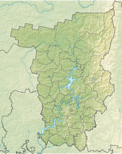
The Kolva is a river in the Perm Territory of Russia , it flows through the territory of the Cherdyn District , the fourth in length and the largest right tributary of the Vishera ( Kama basin) [2] .
| Colva | |
|---|---|
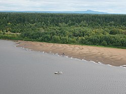 Colva near Cherdyn Colva near Cherdyn | |
| Characteristic | |
| Length | 460 km |
| Pool | 13,500 km² |
| Water flow | 160 m³ / s (137 km from the mouth) |
| Watercourse | |
| Source | |
| • Location | Kolvinsky mountain Kamen , Northern Ural |
| • Height | above 325.1 m |
| • Coordinates | |
| Mouth | Vishera |
| • Location | 34 km on the right bank |
| • Height | 112 m |
| • Coordinates | |
| River slope | 0.3 m / km |
| Location | |
| Water system | Vishera → Kama → Volga → Caspian Sea |
| A country |
|
| Region | Perm region |
| Area | Cherdyn district |
| HWR Code | |
Content
Geography
The source of the river is located in the northeast of the region near the border with the Republic of Komi , on the south-eastern slope of Kolvinsky Kamen mountain (575 m above sea level). The source lies on the watershed of the Caspian and Barents seas , to the north of the source of the Kolva - the headwaters of the Kisunya River.
It flows mainly along the western slope of the Northern Urals and flows into Vishera above Ryabinino , 34 km from the mouth. The general direction of the current is southwest. The length of the river is 460 km, the basin area is 13,500 km², the average height of the catchment is 233 m. The average slope is 0.3 m / km. The width reaches 75 m [3] [4] .
The city of Cherdyn , the villages of Korepinskoe, Iskor , Vilgort , Pokcha , Kamgort , Bigichi are located on the Colve River [4] .
Hydrography
The shores of Colva are steep, with deposits of slate, limestone, sandstone; covered with forests, there are meadows. On the right bank, below the village of Bogatyrovo, are located the village of Fighter and the rock of Fighter at a height of 60 m, and at the village of Tsepiya - Divy Kamen and Divya cave [3] . Below the confluence of the Visherka Colva flows a narrow corridor in steep banks.
In the bed there are shoals, stones, and rapids. In the upper course of the channel is rocky, below the rocky areas alternate with sandy. The water in the river is bright and clear [5] .
Food mixed, with a predominance of snow. It freezes in early November, opens in late April - early May. Alloy. Navigable to high water for 200-250 km from the mouth.
History
The ancient route from the Volga region to the Pechora region passed along Kolva. Between Cherdyn and Nyrob there were found several Wondrous fortifications, in which eastern coins come across, testifying to the importance of Kolva as a means of communication of the ancient Bulgarian kingdom with the distant North [4] . In 1472, on the shores of the Kolva, the Moscow army defeated the army of the Grand Duchy of Perm .
Tributaries
(distance from the mouth)
- 6.4 km: Chudova River (lv)
- 16 km: Kemzelka River ( PR )
- 20 km: river Mudyl (lv)
- 25 km: the river Lyzovka (PR)
- 37 km: River Tsydovka ( PR )
- 51 km: the river Nizva (lv)
- 90 km: the river Bubyl ( PR )
- 100 km: the river Vizhaiha (PR)
- 104 km: Ukhty river (lv)
- 111 km: Tsepiya River ( PR )
- 124 km: river Visherka (PR)
- 154 km: the river Nech ( PR )
- 175 km: Berezovaya River (lv)
- 180 km: Osh river (lv)
- 183 km: Shudya Stream (PR)
- 201 km: the river Gadya ( PR )
- 219 km: the river Big Chulan (pr)
- 225 km: Polusay creek (PR)
- 234 km: the river Visesya (PR)
- 237 km: Chumuk River (lv)
- 246 km: the river Ayia (lv)
- 262 km: Tulpan River (lv)
- 269 km: River Anyl ( PR )
- 277 km: the river Nyuzim ( PR )
- 293 km: Surya River (lv)
- 302 km: the river Sukhotil (Ave)
- 310 km: the river Nerja ( PR )
- 326 km: Kumay River (lv)
- 332 km: river Dumtom (Ave)
- 334 km: Bolshoy Susay River (Ave)
- 351 km: Seleya River (lv)
- 354 km: the river Chishcheva (lv)
- 366 km: Närizi River (Ave)
- 367 km: River Vizya ( PR )
- 372 km: river Lekomzhech (лв)
- 380 km: Yamzhach River (lv)
- 402 km: Kysurya River (lv)
- 406 km: Surya River (lv)
- 441 km: River Uyvazh (in the water register - no name, etc.)
The largest tributaries are the Birch and Vesherka .
Water Registry Data
According to the state water register of Russia, it belongs to the Kama basin district , the water management section of the river - Kama from the water measuring station near the village of Bondyug to the city of Berezniki , the river sub-basin of the river - the tributaries of the Kama to the confluence of the White River. River basin - Kama [7] .
According to the geographic information system of water management zoning of the territory of the Russian Federation, prepared by the Federal Agency for Water Resources [7] :
- The code of the water body in the state water register is 10010100212111100005515
- Hydrological code (GI) - 111100551
- Pool code - 01/10/1,002
- GI Volume Number - 11
- Issue on GI - 1
Notes
- ↑ Surface water resources of the USSR: Hydrological knowledge. T. 11. Middle Ural and Urals. Issue 1. Kama / ed. V.V. Nikolaenko. - L .: Gidrometeoizdat, 1966. - 324 p.
- ↑ Belyavsky P.Ye. , Rudakov V.E. Kama, river // Brockhaus and Efron Encyclopedic Dictionary : 86 t. (82 t. And 4 add.). - SPb. , 1890-1907.
- ↑ 1 2 Encyclopedia of the Perm Region - Kolva (Inaccessible link) . The date of circulation is February 16, 2007. Archived September 28, 2007.
- ↑ 1 2 3 Kolva, river of the Perm province ( ESBE )
- ↑ Ryzhavsky G. Ya. "According to Kame and its tributaries." - M .: Physical Culture and Sport, 1986. - 240 with
- ↑ Kolva At Kolva (English) . R-ArcticNET. The appeal date is January 12, 2018.
- ↑ 1 2 State Water Register of the Russian Federation: Kolva . Archived August 4, 2012.
Links
- Kolva (River in the Perm Region) // The Great Soviet Encyclopedia : [in 30 t.] / Ch. ed. A. M. Prokhorov . - 3rd ed. - M .: Soviet Encyclopedia, 1969-1978.
- Colva, the river of the Perm province // Brockhaus and Efron Encyclopedic Dictionary : 86 tons (82 tons and 4 extra). - SPb. , 1890-1907.
- Colva // Dictionary of modern geographical names / Rus. geogr. oh Mosk. Centre; Under total ed. Acad. V.M. Kotlyakov . Institute of Geography RAS . - Yekaterinburg: U-Factory, 2006.
- The article uses information provided by the Federal Agency for Water Resources from the list of water bodies registered in the state water register as of March 29, 2009. List (rar-archive, 3.21 MB).